
Cycling
Fancy a bit of cycling in a close urban and rural setting? Then Irlam and Cadishead is the place for you!
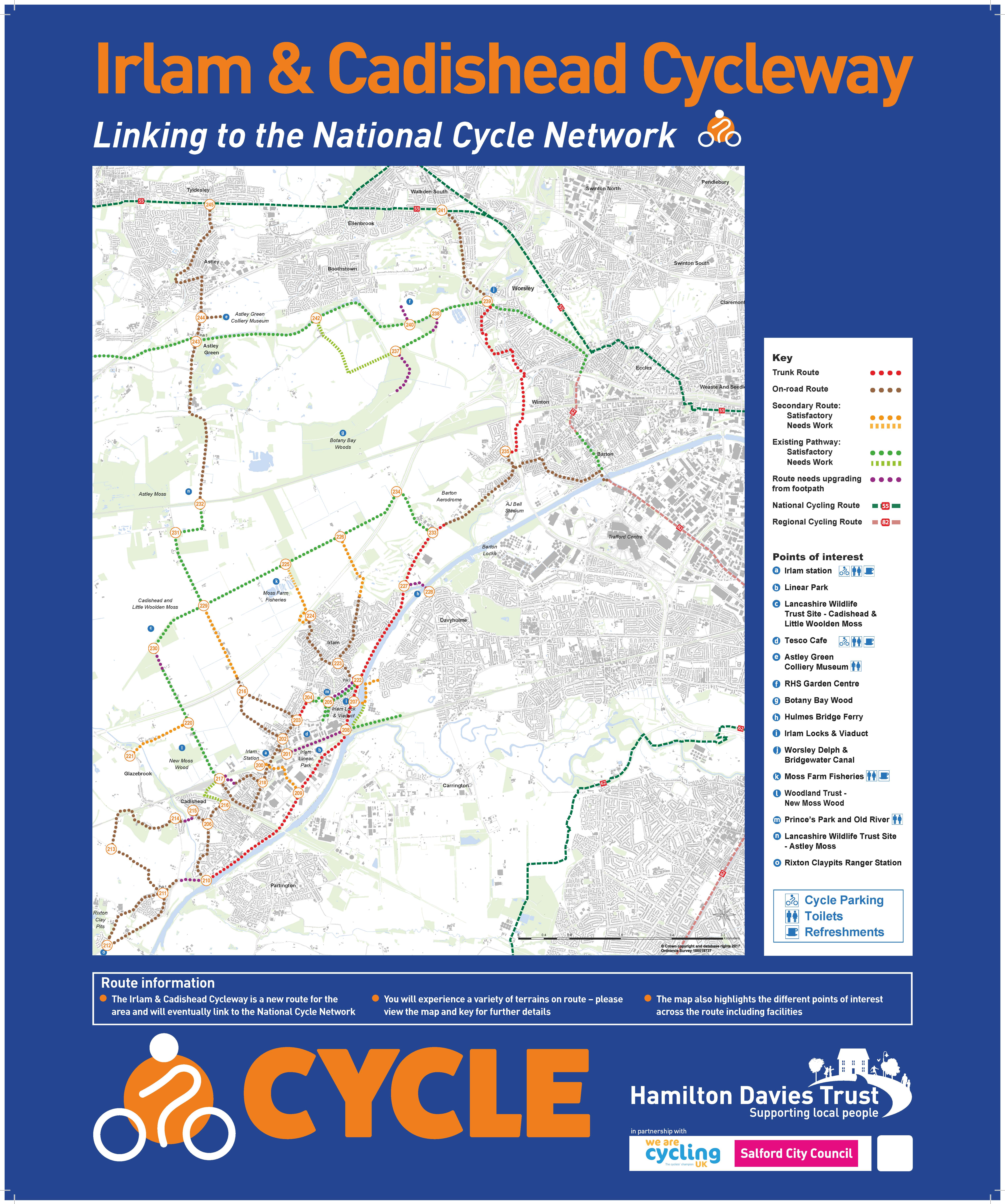
The first phase of the Irlam and Cadishead Cycle Network was launched in April by none other than Olympic Gold Medallist Chris Boardman MBE. The network provides a new route system, with aspirations to link with the National Cycle Network – improving connectivity with other areas.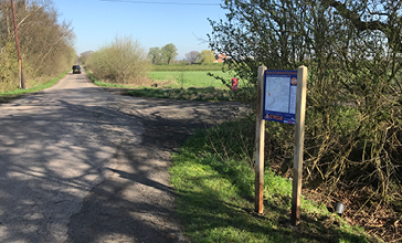
Based on the Dutch cycling model, the aim was to introduce a system that provides flexibility to tailor each route to the riders’ ability, through the use of waypoint and directional signage.
The waypoints will also allow the route to be altered during a ride, either extending or shortening the journey depending on how the rider feels, as well as taking in different points of interest, or stopping for a bite to eat or to use the facilities.
There are currently waypoint signs and posts in the following locations:
| Waypoint | Location | Information |
| 200 | Irlam Station | Irlam Station offers a cycling hub for parking your bike, as well as other facilities including: café bar, toilets, heritage hub and artwork from I C Art. For information on how you can access the cycling hub please visit the Transport for Greater Manchester website |
| 202 | Astley Road | From here you can head up to Chat Moss, where you can take in some of the wonderful nature on Irlam and Cadishead’s doorstep |
| 208 | Linear Park Sub-station | Irlam Linear Park is a hidden gem within the district. Brought back into use by a host of volunteers. The park connects Cadishead Way Bypass with Preston Avenue – opposite Station Road for easy access the station and its facilities. The terrain through the park is undulating and care is advised. Click here to find out more |
| 211 | Hollins Green Community Hall | The hall is at the centre of the village, ideally located opposite the Black Swan Pub offering all day refreshments and just a couple of doors down from the community shop. If you’ve got time, the Hollinfare Cemetery has been awarded green flag status and is a haven of tranquillity. |
| 212 | Rixton Clay Pits | This Site of Special Scientific Interest has woodland and meadow habitats and is home to the Great Crested Newt along with a wide variety of other wildlife. There are viewing points and wildlife information boards throughout the site. Find out more here |
| 216 | Fir Street | The Fir Street waypoint is located near the Sandy Lane bridge, which crosses the disused Cheshire Lines railway line, that used to link Irlam & Cadishead with Partington and Carrington over the Manchester Ship Canal via Cadishead Viaduct |
| 217 | New Moss Road Bridge | Crossing the bridge at New Moss Road takes you out of the Cadishead urban environment and onto Chat Moss, passing New Moss Wood |
| 222 | Boathouse Irlam | A local pub beside the cut off Old River Irwell. From here you can head down the Cadishead Way Bypass and over the Irlam Locks to Flixton. |
| 227 | Hulmes Ferry | Accessed via Cadishead Way Bypass, this location offers a free ferry running between Irlam and Flixton. Bicycles are permitted on the ferry, but this is at the discretion of the ferry captain. |
| 229 | Four Lanes End | Located on Chat Moss, this section of cycleway is based in a rural setting. Known locally as Four Lanes End, the junction is the intersection of Astley Road and Twelve Yards Road. Take a moment to look at the curios around Four Lanes Ends Cottage |
| 230 | Fairview Farm | This point is the gateway to Cadishead, Little Woolden Moss and the Lancashire Wildlife Trust site. Don’t forget to give Charlie a wave as you pass through her garden – she’ll be pleased to see you |
| 233 | Barton Moss | On the Bypass you can go three ways from 23, along the Bypass either way, one leading up towards Eccles, the other to Hulmes Ferry or up onto the moss passing Barton Aerodrome. |
| 234 | Barton Moss / 12 Yards Road | On the moss, you can go back past the Barton Aerodrome back to the Bypass or carry on over the moss going by the M62. |
Alongside the waypoint and posts, we also have 2 informational signs located at Irlam Leisure Centre and Irlam Fire Station.
The network features a variety of terrains: on-road; existing pathways; and trunk routes. Each cycleway is detailed by category on the signage and categorised further into ‘satisfactory’ routes and those that need further work. This enables the rider to plan their route based on specific terrain.
 The map also shows sites of interest on route, or facilities such as toilets and refreshments, which will help to make your journey as pleasurable as possible.
If you decide to take a ride on the Irlam and Cadishead Network, don’t forget to take some photos and share them with us on Facebookand Twitter, using #ICCycleway
It is hoped that the first part of the Irlam and Cadishead Cycle Network can be expanded to form a circa 50km distance between the National Cycle Network routes 55 and 62, including the expanse of Chat Moss. Watch this space….
For more information on led rides coming up across the area, please keep in touch with us on Facebook and also check our page on the Cycle UKwebsite.